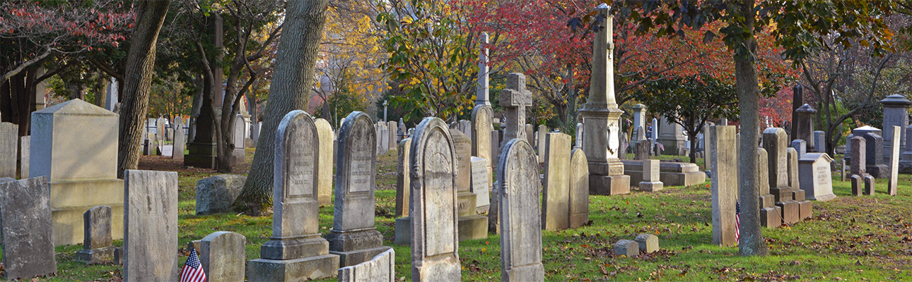
There are seven known historical maps of the New Haven City Burial Ground—or Grove Street Cemetery—documenting the graveyard’s development between its founding year of 1796 and 1932. The earliest two are hand-drawn plans created for the Standing Committee of Proprietors (a governing board representing the lot owners), the next three are printed maps that fold out of booklets on the cemetery published in the nineteenth century, and the last two were created by professional surveyors for the use of Grove Street’s superintendents. All seven maps can be viewed on this page.
The first plan for the “New Burying Ground” was drawn by Josiah Meigs (1757-1822, Yale 1778), who was professor of mathematics and natural philosophy at Yale College from 1794 until 1801, when he moved to Athens to become president of the University of Georgia. His map was mentioned in the minutes of the Proprietors on October 30, 1797:
Noted that the Platt of the New Burying ground, as drawn by Mr. Meigs & laid before this meeting, containing six Tiers of Lots & a vacant Lot on the north west corner, called Potters field, be approved & it is ordered that the same be recorded, & that the several Tiers be numbered progressively from the East side & the Lots progressively from Grove Street northerly.
At the same meeting, the Standing Committee of Proprietors voted that Lot No. 1 in the Third Tier would be conveyed to Yale College, and that Lot No. 1 in the First, Second, and Fourth tiers would be conveyed to the three churches (further awarded by lottery). They also voted that lots in the Fifth Tier would be “appropriated for the burial of Strangers who may die in this City,” for “the deceased poor of this Town who have not title to any other Lot,” and “for people of Colour.” Josiah Meigs was granted Lot No. 3 in the Third Tier for his service to the Proprietors, though he was later appointed the United States Surveyor General by President James Madison and was buried in Arlington National Cemetery.
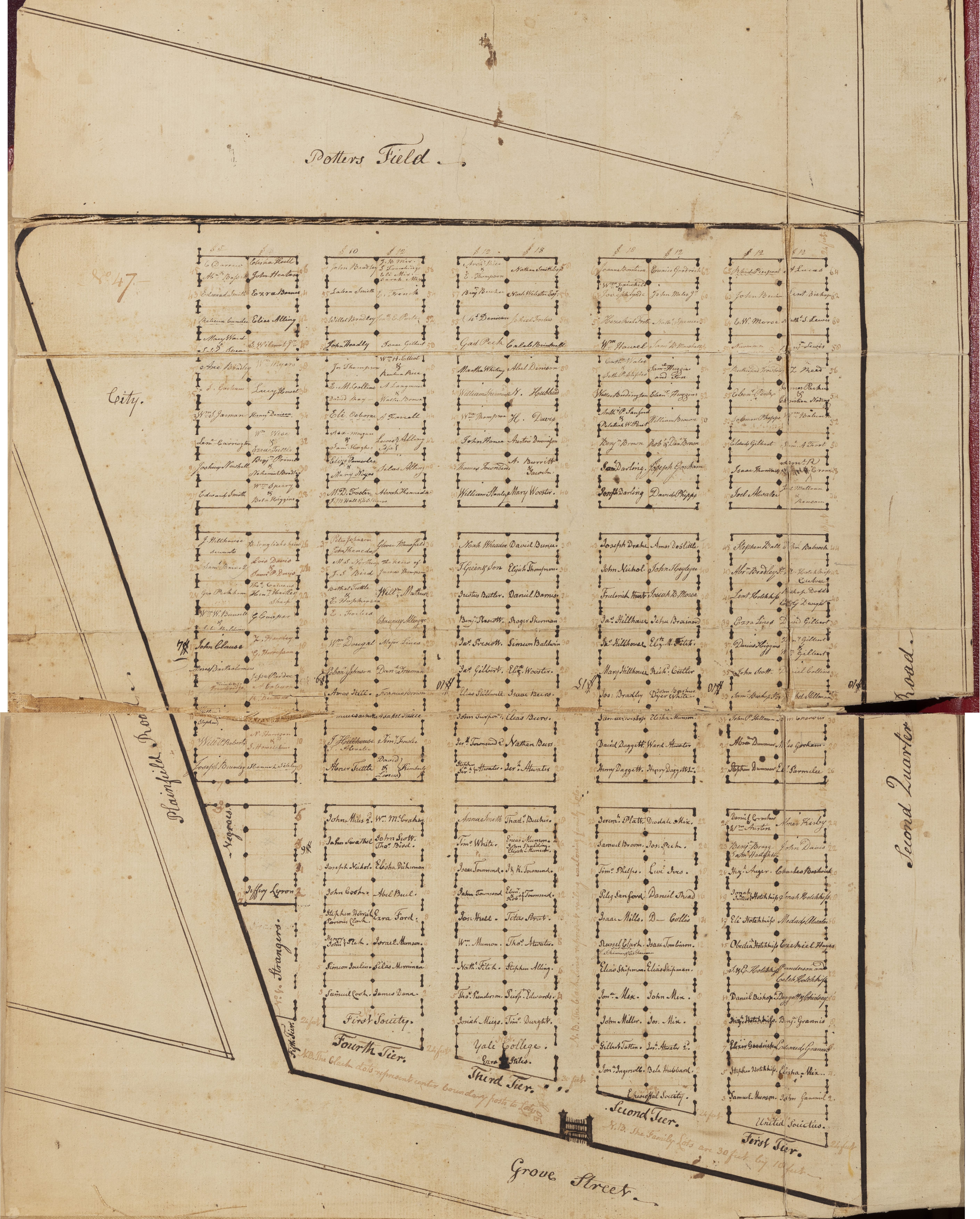
The location of the Meigs “Platt of the New Burying ground” is unknown, but it may be the map shown just below, which was annotated by founding Proprietor James Hillhouse in September 1800.
The map images below may be viewed in high resolution and downloaded for use in publications. To view a map in high resolution, click on the map, and the high resolution version will open in a new window. To download the high resolution image, right-click on it and choose “Save Image” or “Save Image As.”
1800
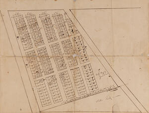 Untitled map, ink on paper, 17 x 22¼ in.
New Haven City Burial Grounds Records (MSS 74), Whitney Library, New Haven Museum
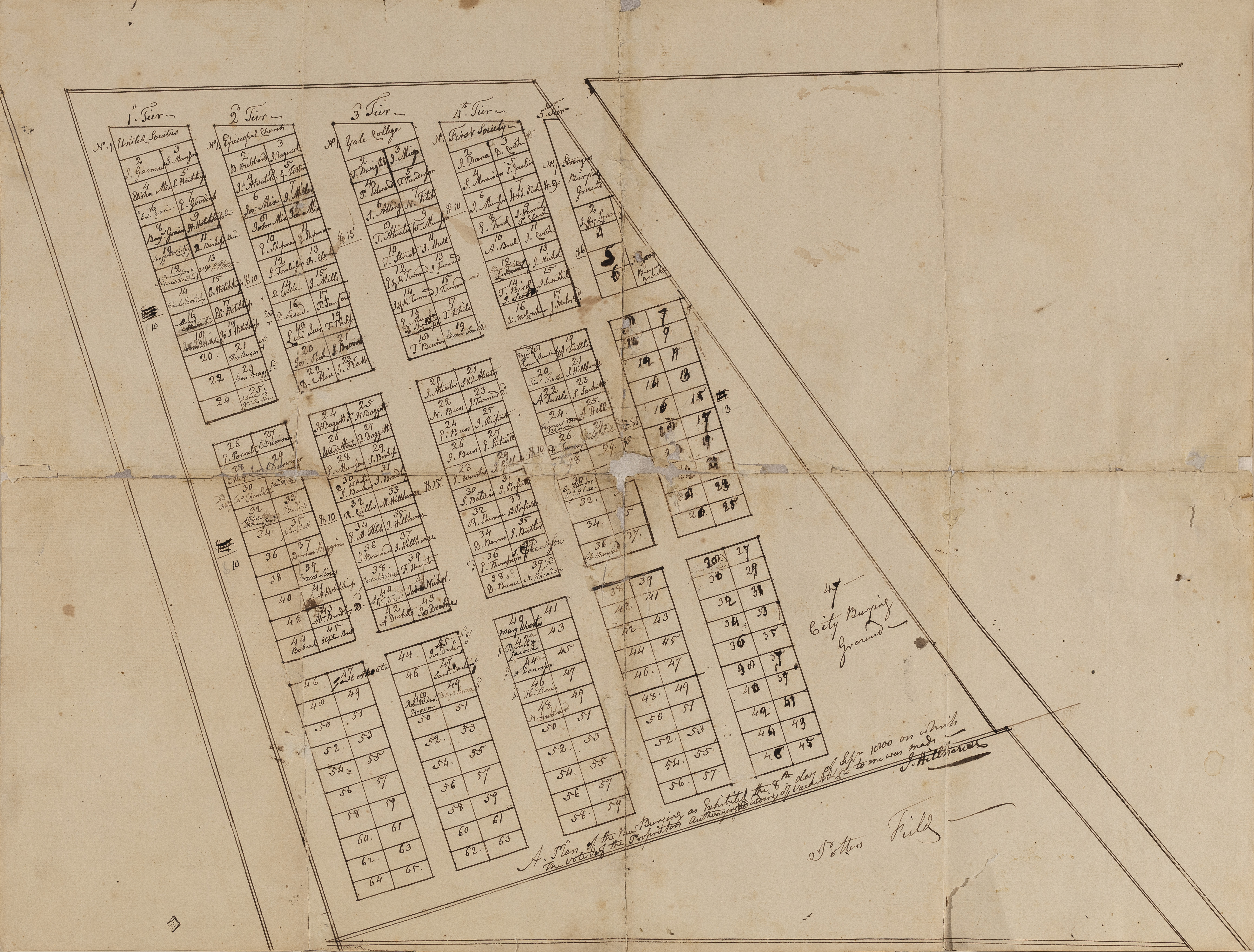
Unlike the other maps that follow, this—the earliest extant plan of the New Burying Ground—is oriented north to south, with Grove Street at the top and Second Quarter Road (now Prospect Street) on the left. It represents just the first ten acres of land that the subscribers had assembled by early October 1797, a little more than half of the eighteen acres the cemetery covers today. The roadway between the Fourth and Fifth tiers is today Central Avenue (where the current entrance gate on Grove Street is located) and the northern line of family lots at the bottom of the map defines what is now Myrtle Avenue, the cemetery’s east-west road. Prices charged for the family lots are shown as well.
The map is undated, but it was annotated by founding Proprietor James Hillhouse at the lower right: “A Plan of the New Burying as Exhibited the 8th day of Sepr. 1800 on which the vote of the Proprietors authorizing the conveying of vacant lots to me was made – J. Hillhouse.” This action is also recorded in the Proprietors’ minutes “by a plan this day exhibited.”
1802
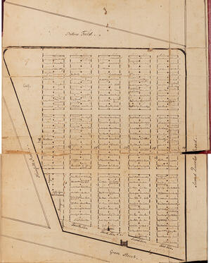 UNTITLED MAP, APRIL 1, 1802, INK ON PAPER, 21½ X 16½ IN.
NEW HAVEN LAND RECORDS VOLUME 56, OFFICE OF THE NEW HAVEN CITY/TOWN CLERK
This hand-drawn plan is an updated and more sophisticated version of the 1800 map, carefully and neatly delineated and featuring a sketch of the entrance gate in the surrounding fence opening on today’s Maple Avenue. Inscribed in lighter ink are the width of the avenues (24 feet) and size of the family lots (30 feet by 10 feet), along with the prices charged for lots: $15 for those along the center avenue, with varying prices toward the edges of the property. Also noted: “The Black dots represent center boundary posts to lots” and “The black lines represent railing enclosing family Lots.” As the map reveals, the cemetery was nearly fully subscribed by April 1802.
The map was cut in half before being bound into a ledger book; here two digital images were joined to recreate its original appearance.
1822
 PLAN OF NEW-HAVEN BURYING-GROUND, LETTERPRESS, 15½ X 17½ IN., FROM PROCEEDINGS OF THE CITY OF NEW-HAVEN IN THE REMOVAL OF MONUMENTS FROM ITS ANCIENT BURYING-GROUND, AND IN THE OPENING OF A NEW GROUND FOR BURIAL (NEW-HAVEN: GRAY & HEWIT, 1822)
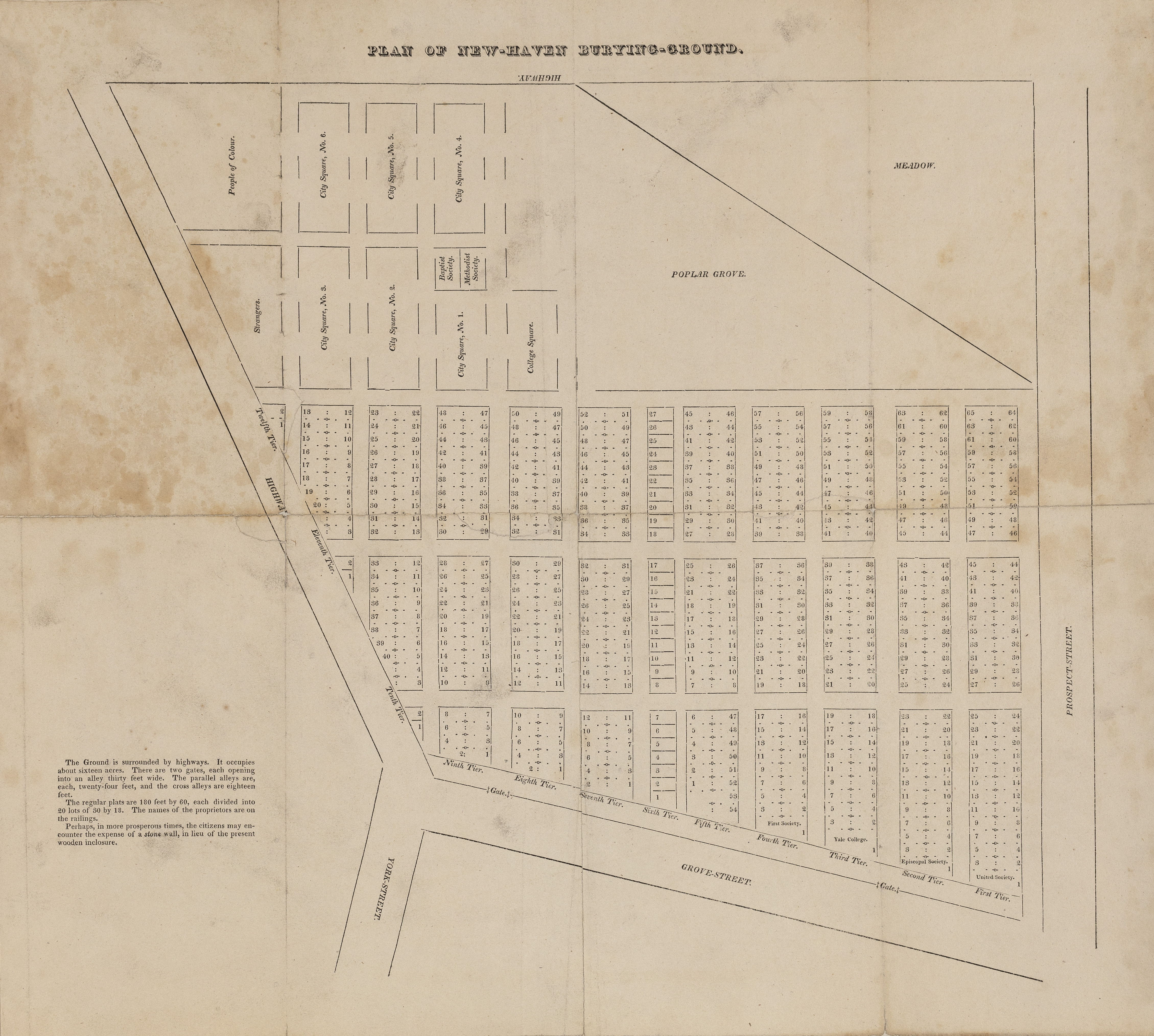
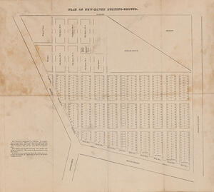
This map reflects the 1814 acquisition of additional land to bring the graveyard up to sixteen acres with a second gate opened in the wooden fence along Grove Street (at today’s Cedar Avenue). Many more family lots were developed, and new sections in the northwest corner were opened for Yale College, Strangers, and People of Colour, as well as for the Baptist and Methodist churches. The six City Square sections were designated for different purposes outlined in the booklet: gravestones removed from the Ancient Burying-Ground on the New Haven Green (those that had not been moved by Proprietors into their own family lots) were placed in No. 1, and burial of citizens “not having family lots” had begun in No. 2, with sections 3 through 6 reserved for future burials progressing in numerical order after No. 2 was filled.
The accompanying booklet provides three lists: names of the deceased whose graves had been covered in 1812 by the new Center Church (accessible today in the crypt beneath the church); the deceased whose gravestones had been moved into the New Burying-Ground in June 1821; and listed by tier and lot number, the names of people who had purchased family lots from 1796 to 1822.
Copies of the map and pamphlet are in the Whitney Library at the New Haven Museum, and the Beinecke Rare Book and Manuscript Library at Yale University.
1839
 PLAN OF THE BURIAL GROUND NEW HAVEN, CON., LITHOGRAPH, 14½ X 23¼ IN., FROM REPORT OF THE COMMITTEE APPOINTED TO INQUIRE INTO THE CONDITION OF THE NEW HAVEN BURYING GROUND, AND TO PROPOSE A PLAN FOR ITS IMPROVEMENT (NEW HAVEN: B. L. HAMLEN, 1839)
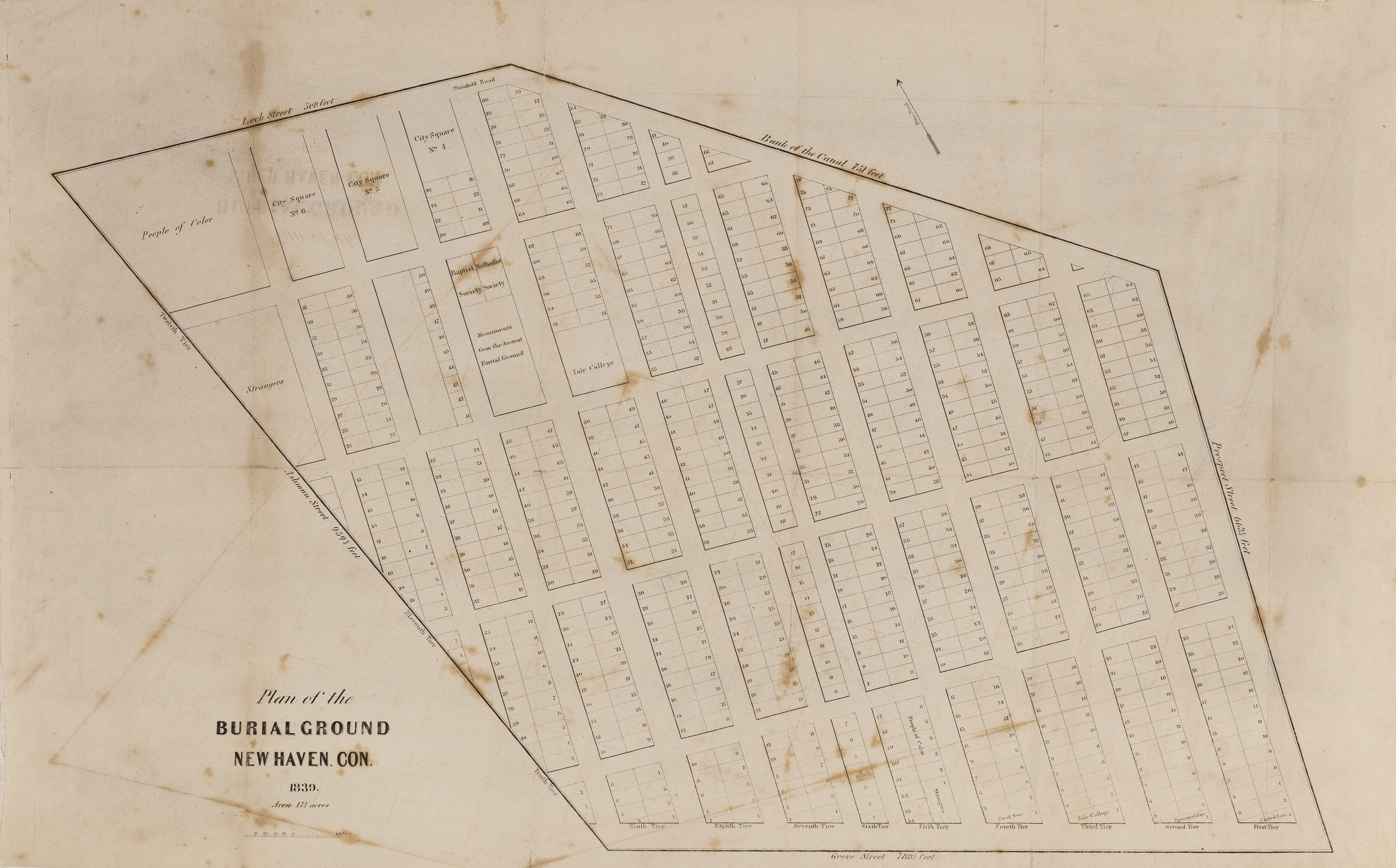
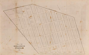
By 1839 the burial ground had achieved its maximum acreage bounded then, as today, by Prospect, Grove, Ashmun, and Lock streets, and by the south bank of the Farmington Canal (now Canal Street); fine dotted lines show where Plainfield Road had been. City Square No. 1 had been assigned to hold monuments moved from the Ancient Burial Ground on the Green, and further development of family lots had taken place in some of the other City Squares.
Copies of the map and pamphlet are in the Whitney Library at the New Haven Museum, the Local History Collection at the New Haven Public Library, and the Beinecke Rare Book and Manuscript Library at Yale University.
1862
 PLAN OF THE NEW HAVEN CITY BURIAL GROUND, LITHOGRAPH, 19½ X 25½ IN., FROM HISTORY OF THE CITY BURIAL GROUND IN NEW HAVEN, TOGETHER WITH THE NAMES OF THE OWNERS OF THE LOTS THEREIN (NEW HAVEN: J. H. BENHAM, 1863)
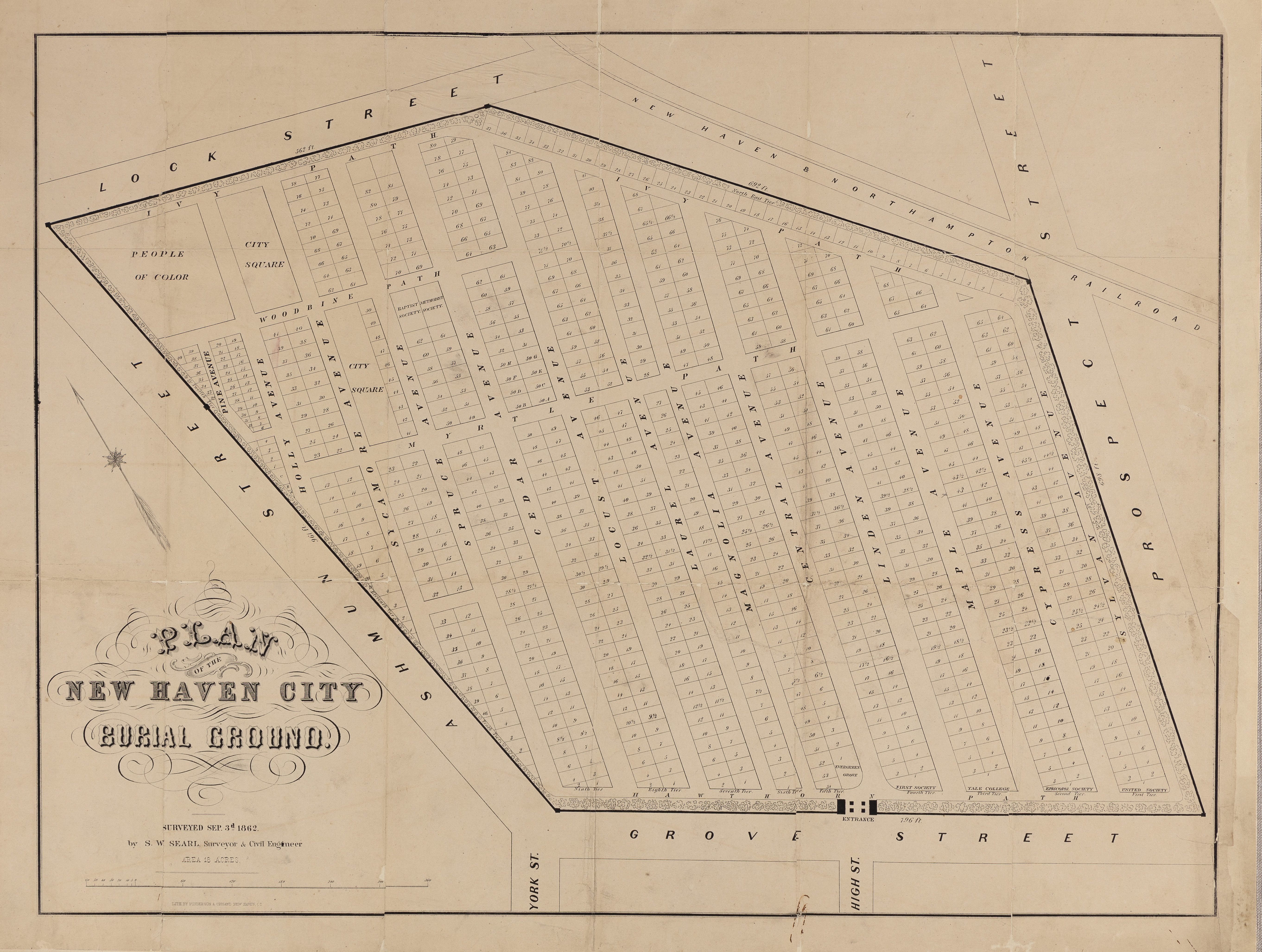
This plan of the cemetery, by surveyor Silas Warner Searle (1822-1902), is the model for the map in use today, and reveals the development of the property up to that date. The stone and iron fence with its Egyptian gateway had been erected in the 1840s, the original crossing alleys had been filled in and sold as family lots, and the avenues had been named for trees. Monuments from the Ancient Burying Ground had been removed from the former City Square No. 1 and that area gridded for family lots, as had been the Strangers section, with a new Pine Avenue cutting down through its center.
Copies of the map and the pamphlet are in the Whitney Library at the New Haven Museum, and the Beinecke Rare Book and Manuscript Library at Yale University.
1897
 Map of the New Haven City Burial Ground, undated photograph by unidentified photographer; 21 x 28 in.
Whitney Library, New Haven Museum
S. W. Searle updated his 1862 survey for this 1897 plan, which is today unlocated but—fortunately—it had been captured in oversize photographs. The map was created at the direction of cemetery superintendent Dwight B. Snow (1869-1958). In a fiftieth-anniversary interview published in the New Haven Register on October 1, 1944, Snow recounted that when he arrived in 1894 as the newly hired sexton, the cemetery was a “a gloomy sight” with overgrown grass, trees, and foliage hiding the headstones, broken wooden fences around lots, and the dirt carriage paths barely passable. He also found the records so incomplete that within his first years he painstakingly “made his way from marker to marker, noting names and dates and enrolling all” in a card catalog index of the interred to use with “a huge map showing every plot and the names of all buried within.” The map, however, simply shows the names of the lot owners much as the 1800 and 1802 plans had before; it does document the family lots that were being developed in the section once reserved for People of Color, the gridding and sale of lots along Prospect and Lock streets, and the appearance of the Chapel (now the cemetery office), which was built in the 1870s.
Two copies of the photograph are held by the New Haven Museum, and one is in Yale University’s University Archives. Surveyor Searle was buried in Evergreen Cemetery, but Superintendent Snow’s family lot is on the corner of Holly and Myrtle avenues in what had formerly been City Square No. 3.
1932
 Map of the New Haven City Burial Ground (Grove Street Cemetery), February 1932
Grove Street Cemetery
This plan, also commissioned by superintendent Dwight B. Snow, was “Compiled from map of 1862 by Searle, old records, investigations and surveys” by New Haven civil engineer and surveyor Alexander Cahn (1875-1934, and buried in Congregation Mishkan Israel Cemetery). Cahn’s map still hangs in the cemetery office, along with a full-size printed reproduction that is in daily use by the superintendent and staff, and by visitors looking to navigate to a particular gravesite.
The cemetery’s official burial records reference Tier and Lot numbers as they have since 1797, but the staff and visitors generally use Avenue and Lot numbers—much like residential street addresses—to locate monuments such as Roger Sherman’s table tomb at 32 Maple Avenue (or Tier Three, Lot 32). On Laurel, Locust, Spruce, and Sylvan avenues, the same lot numbers appear on both sides of the avenue and can cause confusion unless West or East sides are designated; for instance, Samuel St. John’s Egyptian-style mausoleum is at 55 Locust Avenue, West.